 California Water News Daily Your Source For Water News in California

The 2016-2017 water year’s first snowpack measurement came up lacking on Tuesday but super-soaker storms and up to five new feet of snow in the Sierras within the next several days could soon change the measurement’s forecast. Even drought-dry Southern California is expected to see more rain in the next week.
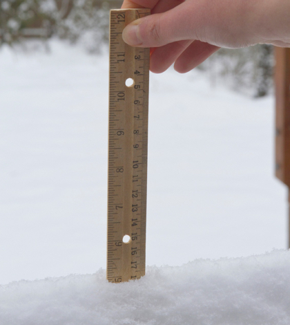
But, for the official record, Tuesday’s manual snow survey at Phillips Station in the Sierra Nevada range by the state’s Department of Water Resources (DWR), showed a snow water equivalence of six inches or 5.3 inches – just over half – of the average early new year total of 11.3 inches. The statewide snowpack holds 7.2 inches of water equivalent, or 70 percent of the January 3 historical average.
Snow water is the theoretical equivalence that would ensue if the entire snowpack melted instantaneously and completely. The measurement is the more important statistic in evaluating the status of snowpack versus its depth.
DWR’s electronic readings on Tuesday, from 105 stations scattered throughout the Sierra Nevada, indicate the water content of the northern Sierra snowpack is 7.2 inches, 68 percent of the multi-decade average for the date. The central and southern Sierra readings are 7.4 inches (65 percent of average) and 6.6 inches (73 percent of average), respectively.
The Phillips Station manual measurement, taken near the intersection of Highway 50 and Sierra-at-Tahoe Road, is primarily a media-oriented snow survey but provides an initial look at the status of the state’s snowpack. Manual measurements supplement the electronic readings from about 100 snow pillows in the Sierra Nevada throughout the winter.
Frank Gehrke, chief of the California Cooperative Snow Surveys Program, said after conducting the Phillips Station survey, “Keep in mind we had pretty much bare ground here about a week ago, with a few patches of snow. Most of the snow we measured today came down in the last couple days and is continuing to come down.” Historically January and February are two of California’s three wettest months.
Gehrke continued his comments, commenting on the coming storms in the next week by saying, “That’s (The storms are) going to bolster the snowpack. I can see us being potentially at average once that series of storms moves through. I think it’s a very encouraging start to the winter, and certainly we’ve had other winters when (Phillips) has been basically a bare field.” Case-in-point was the measurement taken in early January 2014 when there was more bare ground than snow and manual and electronic readings recorded the snowpack’s statewide water content at about 20 percent of average for that time of year.
About two-thirds of the state’s annual rainfall occurs between December and March, according to State Climatologist Mike Anderson. Thus far this year, warmer temperatures during storms have produced more rain than snow in many mountain locations.
“We still have three historically wet months ahead of us,” Anderson said, “so there’s still time for the snowpack to build and improve before it begins to melt, which usually starts happening around April 1.”