 California Water News Daily Your Source For Water News in California

The Center for Western Weather and Water Extremes (CW3E) recently launched new tools focused on forecasting the Atmospheric River (AR) Scale. The new tools offer a 7-day forecast and review of the past 7 days for the AR Scale.
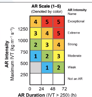
The AR Scale was originally launched in 2019 and is similar to the Saffir-Simpson Hurricane Scale as it categorizes atmospheric rivers on a scale from 1-5. Categories are assigned based on if the storm will potentially be weak (AR 1), moderate (AR 2), strong (AR 3), extreme (AR 4), or exceptional (AR 5).
Storms are characterized by the maximum strength, the amount of water vapor they carry, winds, and their duration in a given location. The scale also indicates if the storm will be beneficial, by relieving drought conditions and refilling water supply, or potentially hazardous, causing flooding and dangerous conditions.
The two new tools are:
1. A forecast of incoming atmospheric rivers and the potential corresponding AR scale ranking at various latitude grid points along the West Coast. Also looks at the past 7 days.
2. A measure of integrated vapor transport (the mix of water vapor and wind that is a signature of atmospheric river storms) at grid points along the West, to give more detail on the magnitude of the storm. Colored shading represents the AR scale observed or forecast for the given time, calculated using the control forecast or ensemble mean.
CW3E created the new AR Scale forecast tools assist water agencies that rely on forecasts for reservoir management. Additional AR forecast tools can be found at: https://cw3e.ucsd.edu/iwv-and-ivt-forecasts/.