 California Water News Daily Your Source For Water News in California

A new storm-weather predicting “atmospheric rivers” (ARs) scale has been created by a team of researchers led by Scripps Institution of Oceanography at the University of California, San Diego (UCSD). The scale was featured in the February 2019 edition of the Bulletin of American Meteorological Society. The bulletin’s abstract indicates that the new scale is “… for the intensity and impacts of ARs. Its utility may be greatest where ARs are the most impactful storm type and hurricanes, nor’easters, and tornadoes are nearly nonexistent.”
Atmospheric rivers are long narrow bands of concentrated atmospheric water vapor pushed along by strong winds. ARs were originally so named by researchers Reginald Newell and Yong Zhu of the Massachusetts Institute of Technology in 1994. The National Oceanic and Atmospheric Administration (NOAA) describes ARS as “relatively long, narrow regions in the atmosphere – like rivers in the sky – that transport most of the water vapor outside of the tropics. These columns of vapor move with the weather, carrying an amount of water vapor roughly equivalent to the average flow of water at the mouth of the Mississippi River. When the atmospheric rivers make landfall, they often release this water vapor in the form of rain or snow.”
The new ARs scale from Scripps Institution of Oceanography at UCSD was developed by F. Martin Ralph, director of the Center for Western Water and Weather Extremes (CW3E) at Scripps, in collaboration with Jonathan Rutz from the National Weather Service and several other experts. The scale assigns five categories for atmospheric rivers using as criteria the amount of water vapor they carry and their duration in a given location.
“We’re on the verge of a historic transformation in understanding how atmospheric rivers can achieve multiple goals in water system operations, including drought relief, groundwater recharge and fisheries health,” said ACWA Executive Director Dave Eggerton. “This newest tool illustrates how we can better prepare for flood events, and maximize opportunities for extra storage.”
The Forecast Informed Reservoir Operations, or FIRO, is a management strategy to improve the performance of reservoirs to provide more reliable water supply for municipal, agricultural, and environmental water needs as well as enhancing the flood protection capacity of reservoirs. Additionally, FIRO is working to improve atmospheric river forecasting and using it to maximize water storage. Currently, a coalition of five member agencies of the Association of California Water Agencies (ACWA) are currently advocating for additional state funding to accelerate advances in FIRO research and capability.
The ARs scale by Ralph, et al., ranks atmospheric rivers from 1 to 5 and creates the categories “weak,” “moderate,” “strong,” “extreme,” and “exceptional.” It uses amounts of water vapor within an atmospheric river as its basis and a period of 24 to 48 hours as its standard measurement of duration. The scale ranks ARs as follows:
- AR Cat 1 (Weak): Primarily beneficial. For example, a Feb. 2, 2017 AR hit California, lasted 24 hours at the coast, and produced modest rainfall.
- AR Cat 2 (Moderate): Mostly beneficial, but also somewhat hazardous. An atmospheric river on Nov. 19-20, 2016 hit Northern California, lasted 42 hours at the coast, and produced several inches of rain that helped replenish low reservoirs after a drought.
- AR Cat 3 (Strong): Balance of beneficial and hazardous. An atmospheric river on Oct. 14-15, 2016 lasted 36 hours at the coast, produced 5-10 inches of rain that helped refill reservoirs after a drought, but also caused some rivers to rise to just below flood stage.
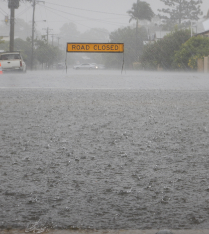
- AR Cat 4 (Extreme): Mostly hazardous, but also beneficial. For example, an atmospheric river on Jan. 8-9, 2017 that persisted for 36 hours produced up to 14 inches of rain in the Sierra Nevada and caused at least a dozen rivers to reach flood stage.
- AR Cat 5 (Exceptional): Primarily hazardous. For example, a Dec. 29 1996 to Jan. 2, 1997 atmospheric river lasted over 100 hours at the Central California coast. The associated heavy precipitation and runoff caused more than $1 billion in damages.
Ralph indicates that unlike other weather scales the atmospheric river scale accounts not only for storms that can prove hazardous, but also for storms that can provide benefits to water supply. He contends that the scale could provide a crucial tool to officials with an operational need to assess flood potential in their jurisdictions before storms strike. It could prove a valuable tool for California’s farmers and emergency personnel; roughly 80 percent of levee breaches in California’s Central Valley are associated with atmospheric rivers when they reach land.
“Forecasters in the western U.S. have been using the concept of ARs in their forecasting for a few years now, and many have been looking for a way to distinguish beneficial from hazardous AR storms,” said Rutz. “The scale was designed partly to meet this need, and it is anticipated that it will be used extensively.”
“This scale enables improved awareness of the potential benefit versus hazard of a forecast AR,” said co-author Michael Anderson of the California Department of Water Resources. “It can serve as a focal point for discussion between water managers, emergency response personnel and the research community as these key water supply and flood inducing storms continue to evolve in a changing climate.”