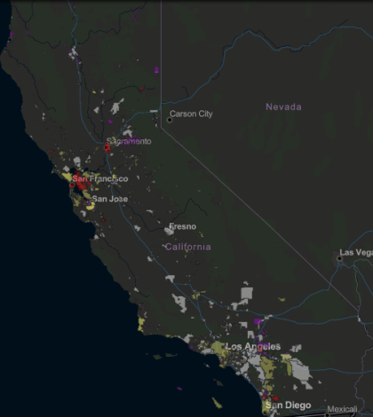
Released Friday, the State Water Resources Control Board (SWRCB) has launched a new digital map that highlights which community water systems in the state have reported the presence of lead pipes and fittings. The submission of information regarding the presence of lead pipes and fittings fulfills a requirement of Senate Bill 427. SB 427 required community water systems to submit the results of a lead user service line inventory to the SWRCB’s Division of Drinking Water by July 1, 2018.
The digital map has compiled data from some 3,000 community water systems throughout California and places the information on the easy-to-read, color-coded map. The document is expected to change as testing continues statewide and additional information is submitted to SWRCB’s Division of Drinking Water.
“The good news is that we only have four water systems that report having lead lines,” said Kurt Souza assistant deputy director for drinking water operations in Southern California. He added, another 31 water systems have lead fittings. “The State Water Board doesn’t anticipate seeing much more lead (to be) found,” said Souza, “based on the data reviewed so far.”
The first generation of the digital map indicates that the majority of the of the lead pipes and fittings are located in the Sacramento and San Francisco Bay areas. Much of this pipework was installed during World War II and soon there afterward. Lead pipes were banned in the 1980s.
The data for the new map were collected in a 2017 electronic annual report. Those water systems with lead pipes and fixtures are required to provide the SWRCB with a schedule for pipework replacement by July 1, 2020.
The new online map is user friendly for general public. Clicking on a certain are reveals a pop-up window that provides the currently available information. Viewers can easily determine the state of pipes and fittings in their service area — provided the full information was submitted by the July 1, 2018 deadline.
Thus far, many water systems are entirely lead-free. However, many community water systems’ filings lack complete information. Nearly 400 water systems have yet to provide enough complete data to provide an accurate picture of how much lead piping remains in the water supply infrastructure. Additionally, 31 systems have been identified as having lead fittings. The digital map easily allows viewers to determine the current status of their area’s water by color-coded categories of purple (inventory incomplete), red (one or more lead service lines or fittings), blue (no lead/no unknown materials service lines or fittings) and beige (one of more unknown service lines or fittings).
Souza has acknowledged that the data and information submitted thus far included plenty of omissions, errors and critical data fields left blank. SWRCB staff will spend the next several calling water systems to confirm the data as well as collecting the needed information to provide a more accurate and robust tool.
California has been addressing the issue of lead in the water in a multitude of ways in the past several years. Legislation has been passed requiring testing for lead in the drinking water at schools and, most recently, daycare facilities. The SWRCB has and is awarding millions in grants for schools in economically disadvantaged areas to replace lead fixtures or offer alternative ways to access safe drinking water.
The state anticipates updating the digital lead map to be updated as additional information is submitted in the coming months. To view the current map, go to: https://gispublic.waterboards.ca.gov/portal/apps/Cascade/index.html?appid=7adcfc6473614ada9c0b9c351362a656.
 California Water News Daily Your Source For Water News in California


